COLOMBO

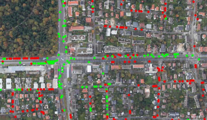
Urban traffic control (UTC) systems aim at enabling safe and efficient passing of the ever increasing road traffic flows at intersections and elsewhere. This requires determining the situation on the roads. Emerging cooperative techniques like vehicle-to-infrastructure (V2I)...

Waiting or Parking?

05.02.2018 · Großereignis- / Katastrophenmanagement
In the VABENE++ project, traffic information is collected automatically from aerial photographs. An approach has now been developed to separate parking from queuing vehicles, thus improving the quality of the results.

Swarmtool in Action

18.01.2018 · Großereignis- / Katastrophenmanagement
VABENE++ has developed a system for an area-wide mapping of larger areas that allows the simultaneous operation of several multicopters at the same time. The Swarmtool has now been extensively tested and optimized.

Uninterruptible Data Transmission via Laser

18.01.2018 · Großereignis- / Katastrophenmanagement
In the VABENE++ project enormous amounts of data are generated during aerial photography flights. In order to be able to send them quickly and without interruptions to the ground, a hybrid link has been developed that enables transmission both by laser and radio transmission and...

Bluetooth Sensors for Traffic Management

18.01.2018 · Großereignis- / Katastrophenmanagement
Vabene++ supports the city of Constance in collecting traffic data using its own bluetooth sensor technology. The data obtained flows into a simulation model for the evaluation and optimization of traffic management measures.

When Multicopters Swarm Out

18.01.2018 · Großereignis- / Katastrophenmanagement
More and more multicopters are being used to gain an overview of the situation in crisis situations. In order to record larger areas or different locations at the same time, VABENE++ is developing the Swarmtool, which is used to control swarms of such multicopters.

New Aerial Camera System for Civil Protection

18.01.2018 · Großereignis- / Katastrophenmanagement
The new camera system for the DLR research helicopter FHS is ready for use. The aim of the system is to acquire aerial images for situation assessment and to make the products available directly on site in order to support customers in case of major events and catastrophes.