Mobility Analysis and Evacuation Planning
Expand the decision support system to include information on freight and passenger transport:
- Provide information on freight traffic, taking into account road and rail traffic as well as harbours and airports as trans-shipment points
- Estimate the transport volumes for supplying rescue teams and determine how they can be distributed considering current infrastructure availability and revised routes
- Find suitable transfer and interim storage points for assuring the production of goods and supplying the population
- Generate evacuation plans automatically based on a multimodal mobility analysis (simulation of road traffic and local public transportation for given regions and scenarios).
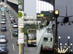
Expand aerial monitoring
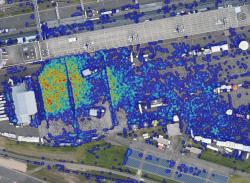
- Develop and implement an automated procedure to detect human aggregations in order to ward off dangerous situations
- Develop and implement a procedure to extract expanses of water from optical and radar images, and to assess precisely specified open areas (for tents, vehicles and other objects) and the suitability and usability of roads and rescue routes from optical data
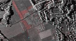
- Develop and implement procedures to automatically distinguish between parked vehicles and those immobilized because of the traffic situation in order to more reliably identify traffic parameters
Expand the spectral range around the near-infrared wavelengths to more accurately distinguish water, vegetation and traffic zones - Expand the sensor complement of helicopter systems with a 4k video function for longer monitoring of specific objects
- Use zoom lenses to capture local details
- Document in real time with optical systems the terrain in 3D in order to detect changes in the land surface during disasters such as slope collapse and to improve traffic data extraction in urban areas
- Fuse MAV and 3K/4k aerial images to increase the precision of MAV image data and obtain a more detailed overall view.
Develop a more compact and powerful V-SAR radar system
- Develop and construct a powerful, compact and operationally usable multichannel V-SAR radar system that can on principle also be used on small aircraft
- Improve the rate of vehicle detection and reduce the number of false identifications by simultaneous multichannel operation, modifying existing signal processing algorithms, and developing new ones with real-time capabilities
- Develop a traffic processor that does not depend on a street database, making it possible to detect off-road vehicles and those on non-catalogued roads
- Generate high-resolution, fully polarimetric radar images (improved geometric resolution down to ca. 10 x 10 cm independent of altitude) that can be used for infrastructure analysis and change detection
- Further optimise and operationalise the entire radar processing chain, taking into account real-time aspects.
Operationalise existing systems
- Expand the Web-based applications available from the ZKI portal by offering interactive map generation and print functions
- Change over to uninterrupted around the clock operation of existing systems.